Strongest impacts expected in January and February, 2016.
San Jose Mercury News/Science and Environment/Paul Rogers, 10/8/15. "El Nino" when will it start raining in California?"
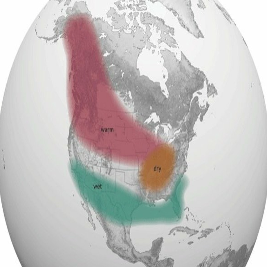 |
| Above average rain expected, January, February, (and maybe March, as was the case in 1983). Red = warm; orange = dry; green = wet. |
 |
| El Nino conditions: left 10/5/1997; right 10/4/1915. |
.... El Niño is a disruption in the weather patterns over the Pacific Ocean, when the ocean's surface warms more than normal. Those warm waters release heat, changing wind directions and the jet stream, which often brings more and wetter storms to California. Halpert agreed that this year, if big storms come, they aren't likely to come any earlier than in a normal winter." Read more.
Related article - San Francisco Chronicle/SF Gate/Kurtis Alexander, 10/8/15."This year's El Nino still looks like a whopper." Federal forecasters on Thursday reinforced expectations of a strong El Niño this winter, saying there’s a 95 percent chance the burly weather phenomenon, often linked to rain in California, sticks around until spring. Equatorial waters in the Pacific remain extraordinarily warm and trade winds that typically push balmy seas away from the Americas remain weak. The conditions portend an El Niño on par with the giants in 1997-98 and 1982-83, according to the U.S. Climate Prediction Center. In the past, strong El Niños have correlated with above-average rain in the southern United States, with Southern California often a landing pad for major storms and floods. Northern California has historically been less affected by El Niño, though the stronger the system, the higher the chances of rain."
Reference. Comparison with 1997. Live Science/Jeanna Bryner, Managing Editor, 10/14/15, "Upcoming El Nino may be as wild as 1997 event." "Whether El Niño gets slightly stronger or a little weaker is not statistically significant now. 'This baby is too big to fail', Bill Patzert, a climatologist at NASA's Jet Propulsion Laboratory in Pasadena, California, told NASA's Earth Observatory."
Reference, El Nino description. State of CA Wildlife/Conservation/Marine/El Nino, "What is El Nino?" "El Niño is a naturally occurring event in the equatorial region which causes temporary changes in the world climate. Originally, El Niño was the name used for warmer than normal sea surface temperatures in the Pacific Ocean off the coast of South America. Now, El Niño has come to refer to a whole complex of Pacific Ocean sea-surface temperature changes and global weather events. The ocean warming off South America is just one of these events." University Corporation for Atmospheric Research, see "What is El Niño, and what is La Nina?" "El Niño is a warming of the central to eastern tropical Pacific that occurs every two to seven years, on average. The term also commonly refers to the atmospheric rearrangements that occur with the oceanic warming. During an El Niño event, sea surface temperatures across a watery expanse often as large as the United States can warm by 1–3°F or more for a period of from a few months to a year or two. .... La Niña, the counterpart to El Niño, is a cooling of the waters across the same region. As with El Niño, the term La Niña typically is used to refer to the associated atmospheric as well as oceanic patterns. It often lasts longer than El Niño, sometimes persisting or recurring for two or more years."
Note photo/graphic. Image #1 of 58 from the related San Francisco Chronicle/SF Gate article, from NOAA Climate.gov. "National Oceanic and Atmospheric Administration report released Thursday predicts a greater than 95 percent chance that El Niño will last through the winter and into the spring and pack above average rain..." 1997-1915 comparison is from the referenced Live Science article abpve (from NASA Earth Observatory).
Posted by Kathy Meeh


No comments:
Post a Comment